Eyeing a home that backs to a winding ribbon of water on Johns Island? If the listing mentions a “tidal creek,” you are looking at one of the Lowcountry’s most distinctive waterfront settings. You get scenery, wildlife, and often a chance to launch a kayak right from your backyard. In this guide, you will learn what a tidal creek lot is, how it differs from marshfront and deepwater, what to expect with tides and docks, and how to evaluate a specific parcel before you buy. Let’s dive in.
Tidal creek defined
A tidal creek is a narrow, often curving channel that fills and drains with the ocean tides. On Johns Island, these creeks thread through salt marsh and connect to larger tidal rivers like the Stono and Kiawah waterways, then to Charleston Harbor and the Atlantic. The water is brackish to salty, and the banks are shaped by marsh vegetation and sediment.
If your lot fronts a tidal creek, you likely face a defined channel rather than a broad open marsh. The creek may be a few feet to several tens of feet across. At high tide it feels like classic waterfront. At low tide, parts of the channel may become shallow or even expose mud.
How creek lots look
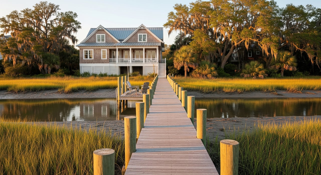
Tidal creek lots usually back to a natural marsh edge with cordgrass and salt‑tolerant plants. Shorelines can include a simple access walkway, a piling‑supported pier, small float, or in some cases riprap for stabilization. Vertical seawalls and bulkheads are less common on marsh edges and are closely regulated.
You will see abundant wildlife. Expect herons, egrets, ospreys, and seasonal shorebirds. The setting is peaceful and feels buffered from roads and neighbors.
Creek vs marshfront vs deepwater
Understanding the difference helps you match lifestyle and expectations.
- Marshfront: Broad marsh views with no defined channel in front. It is beautiful and open but usually not navigable for boats. The appeal is scenery and wildlife.
- Tidal creek: A visible channel with intermittent, tide‑dependent access for small craft. Views are more intimate but still very scenic.
- Deepwater: Consistently navigable at low tide and suitable for larger boats. These lots front a wide river or harbor channel and carry a different permitting and insurance profile.
Tides, depth, and boats
Water levels on Johns Island rise and fall twice daily with the tides. A creek that is boatable at high tide may be shallow or even muddy at low tide. The local tidal range spans multiple feet, so your usable boating window will change through the month and with seasons or storms.
Depth is not static. Creeks can shoal as sediment moves, vegetation spreads, and storms reshape channels. Smaller creeks tend to shoal faster. Some communities or owners pursue maintenance dredging, which requires permits and can be costly.
What boats work best? Kayaks, canoes, paddleboards, Jon boats, skiffs, and flats boats are typical winners. Small outboards can work if your local channel holds enough depth at mid to higher tides. Larger powerboats, sailboats, and yachts usually need deepwater frontage or a marina.
For timing, check reliable tide data. The region’s tides are predictable, and resources like the NOAA Tides & Currents tide predictions help you plan windows for launching and returning.
Dock options and permits
Whether you can build a dock, and what type, depends on site conditions, property rights, and approvals from multiple agencies.
- Typical solutions: Open‑piling piers, short walkways, small floats, and ladders for kayaks and skiffs.
- Design drivers: Creek width and depth, the distance from upland to the channel, and room to position a small float without blocking the creek.
- Permits and reviews: Projects in tidal waters and marsh usually require review by the SCDHEC Office of Ocean and Coastal Resource Management and often the U.S. Army Corps of Engineers, Charleston District. Charleston County may add zoning, building, and setback requirements through Planning & Zoning.
Open structures supported by pilings are commonly preferred to keep water flowing and wildlife moving. Vertical seawalls and bulkheads along marsh edges are often restricted.
Lifestyle perks to love
Tidal creek living is a daily reminder that you are in the Lowcountry. Beyond the view, there are practical benefits.
- Recreation at your fingertips: Launch a kayak or paddleboard on the high tide and explore. Depending on season and site, you may enjoy inshore fishing or crabbing.
- Wildlife and scenery: Regular sightings of wading birds, shorebirds, and estuarine species make the setting feel alive.
- Natural privacy: Marsh and creek corridors create a soft buffer between you and nearby development.
- Modest access structures: Compared with marina berths or large docks, small‑craft setups can be lower impact and simpler to maintain.
For background on local ecology and living with salt marsh, the South Carolina Sea Grant Consortium and South Carolina Department of Natural Resources offer helpful context.
Practical drawbacks to weigh
Every waterfront type has tradeoffs. With tidal creeks, keep these in mind.
- Tide‑dependent access: You may only float a skiff during certain tide windows, and you might trailer larger boats to deeper water.
- Shoaling and maintenance: Shallow creeks can fill in and sometimes need regulated, expensive maintenance dredging.
- Flood and surge risk: Creek‑edge lots are low‑lying and often within FEMA flood zones. Elevated construction and flood insurance are common.
- Coastal exposure: Expect more mosquitoes at times, plus salt spray that can affect landscaping and exterior materials.
- Shoreline limits: Regulations may restrict structures that change marsh hydrology.
Buyer checklist for Johns Island
Before you fall in love with the view, confirm the details that drive daily use and long‑term value.
- Frontage type in deed and plat. Confirm whether the parcel includes riparian rights to the creek bank and whether frontage is described as tidal creek versus marshfront.
- Depth at mean low and mean high water. Ask for recent depth soundings or a marine survey. Visit at low and high tide to see real conditions.
- Channel to deeper water. Identify a natural or maintained path to larger rivers. Neighbor docks and small boats can be clues.
- Permits on existing structures. Verify as‑built permits for any dock, walkway, or shoreline work.
- Flood zone and insurance. Review FEMA flood maps and get an insurance quote based on current elevation and building plans.
- Easements and community agreements. Look for shared dock or dredging agreements that affect future costs or use.
- Septic or sewer. Verify capacity and placement if the property relies on septic.
- Neighbor practices. Ask nearby owners about dredging history, typical tide windows, and storm impacts.
Local experts and resources
A short list of who and what to consult during due diligence:
- Marine contractor or coastal engineer: Depth checks, dock concepts, feasibility, and ballpark costs.
- Licensed surveyor: Boundary confirmation, riparian lines, and tidal datum references.
- Environmental or permitting consultant: Guidance on state, federal, and county approvals.
- Home inspector with coastal experience: Systems, moisture, and elevation considerations.
- Tide and coastal data: NOAA Tides & Currents.
- State coastal permits: SCDHEC‑OCRM.
- Federal permits: U.S. Army Corps of Engineers, Charleston District.
- County planning and maps: Charleston County Planning & Zoning and Charleston County GIS.
How to research a parcel
Move from curiosity to clarity with a simple process:
- Pull the Charleston County parcel record and GIS map to review boundaries, shoreline, and FEMA flood zone.
- Request the survey and any site plans from the seller or listing agent. Look for mean high water and mean low water lines if shown.
- Check tide charts using NOAA Tides & Currents and visit at both low and high tide. Note depth, shoaling, and exposed mud.
- Talk to neighbors or a nearby marina about typical depths, dredging history, and the route to deeper water.
- Get a preliminary opinion from a marine contractor on dock options, likely permitting path, timeline, and ballpark costs.
- Verify permits for any existing dock or shoreline work and ask if there are conservation easements or riparian restrictions.
Plan for future conditions
Sea level and storm patterns affect all Lowcountry waterfronts over time. These factors influence flood insurance, future permitting, and maintenance needs. Tools like the NOAA Sea Level Rise Viewer and county hazard maps help you understand long‑term exposure as you plan improvements and ownership timelines.
The bottom line
A tidal creek lot on Johns Island blends natural beauty with hands‑on coastal living. You get quiet waterways, abundant wildlife, and a front‑row seat to the tides. In return, you accept tide windows, careful dock design, and thoughtful planning for flood and maintenance. With clear due diligence and the right team, it can be a rewarding way to enjoy the Lowcountry.
If you want to weigh a specific property or align a lot with a future custom build or renovation, our integrated approach makes the process simpler. Connect with King & Society Real Estate to explore Johns Island tidal creek homes and move from research to reality.
FAQs
What is a tidal creek lot on Johns Island?
- A tidal creek lot fronts a narrow channel that fills and drains with the tides, offering scenic water frontage and tide‑dependent access for small craft.
How does a tidal creek differ from marshfront?
- Marshfront faces broad marsh with no defined channel for boating, while tidal creek frontage includes a channel that may allow small‑craft access during higher tides.
Can you build a dock on a Johns Island tidal creek?
- Often yes for pilings‑based structures sized for kayaks and skiffs, subject to site depth, property rights, and permits from SCDHEC‑OCRM, the U.S. Army Corps, and Charleston County.
What boats work on tidal creeks near Charleston?
- Kayaks, canoes, paddleboards, Jon boats, skiffs, and flats boats are typical; larger powerboats and sailboats usually require deepwater access or a marina.
Are tidal creek properties flood‑prone on Johns Island?
- Many are in FEMA flood zones due to low elevations and storm surge exposure, so elevated construction and flood insurance are common considerations.
Do tidal creeks require dredging to maintain access?
- Some do. Smaller creeks can shoal over time, and maintenance dredging may be needed, which is regulated and can be expensive.
What should buyers check before closing on a creek lot?
- Confirm frontage and riparian rights, depth at low and high tide, channel connectivity, existing permits, flood zone and insurance, easements, and neighbor maintenance practices.